2012 Maritime Heritage Expedition to Papahānaumokuākea

The 2012 Maritime Heritage Team (L to R): Susie Holst (NOAA), Bert Ho (NPS), Cathy Green (NOAA), Jason Raupp (Flinders University), Kelly Gleason (NOAA), Stephani Gordon (Open Boat Films). Credit: NOAA/Carmen Greto
2012 was another successful year for maritime heritage fieldwork in the Northwestern Hawaiian Islands. The 2012 Maritime Archaeology expedition to Papahānaumokuākea included a six person maritime archaeology team working alongside an apex predator tracking and tagging team, a team studying coral disease, and an alien invasive species survey team. All teams conducted research at French Frigate Shoals, Pearl and Hermes Atoll, Midway Atoll, and Kure Atoll in the Northwestern Hawaiian Islands over the course of 21 days at sea on the NOAA research vessel Hiʻialakai.
The maritime archaeology team included a group of scientists with several years of experience working in the Northwestern Hawaiian Islands. They accomplished several important tasks including exploration for new shipwreck and sunken aircraft sites, documentary filmmaking, ecological survey of maritime heritage sites, and further documentation and survey of known shipwreck sites such as the Nantucket whaleship Two Brothers. The team included P.I. and team lead Dr. Kelly Gleason (NOAA/PMNM), maritime archaeologists Cathy Green (NOAA/ONMS), Bert Ho (NPS/SRC) and Jason Raupp (Flinders University), as well as science filmmaker Stephani Gordon (Open Boat Films), and biologist Susie Holst (NOAA/CRCP).

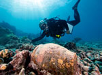
Maritime archaeologist Kelly Gleason examines one of four trypots at the Two Brothers shipwreck site at French Frigate Shoals while filmmaker Stephani Gordon collects film footage for a short documentary film. Credit: NOAA/Bert Ho
While at French Frigate Shoals, the maritime archaeology team continued survey and documentation of the Nantucket whaleship Two Brothers, wrecked at French Frigate Shoals in 1823. The team documented new artifacts at the site, and collected photographs and high definition video footage for the purposes of a documentary film about the shipwreck. The documentary film, developed in collaboration with Open Boat Films will share the story of the Two Brothers shipwreck site, its history and archaeological investigation. To date, the list of whalecraft discovered at the shipwreck site continues to grow. This inventory acts as further confirmation of the ship's identity and provenience as the Two Brothers whaleship sailing from Nantucket, MA.
Bert Ho of the National Park Service's Submerged Resources Center supported the 2012 project with remote sensing expertise and led a magnetometer survey for sunken aircraft sites in the NWHI. The remote sensing survey yielded 43 linear nautical miles of magnetometer survey at Midway Atoll. This includes both the area east of Eastern Island at Midway and the area north of the atoll. The result was over 35 anomalies indicating potential maritime heritage sites. These anomalies will be surveyed in future expeditions.
While at Midway Atoll, the team also investigated a sunken aircraft site reported by NOAA NMFS CRED's marine debris removal team, who discovered the site while surveying for marine debris at Midway Atoll in 2012. The maritime archaeology team documented the sunken aircraft site with photographs, video and the creation of a site plan. Interpretation is ongoing, and the site is an exciting addition to the physical remains of WWII aircraft resting on the seafloor at Midway Atoll that help to tell the story of an important period of history in the NWHI.
Favorable weather and an experienced team contributed to an incredibly successful maritime heritage expedition in 2012. Site interpretation and product development are ongoing following a busy 2012 field season in the Northwestern Hawaiian Islands. Exploration and survey conducted in 2012 help us to better understand our maritime heritage in the NWHI, and open windows up to the long ago past in these remote atolls of the Hawaiian Archipelago. Updates and final products will be posted to the Monument's website.

Filmmaker Stephani Gordon of Open Boat films documents maritime archaeologists surveying the Two Brothers shipwreck site at French Frigate Shoals. Credit: NOAA/Bert Ho

Maritime archaeologist Cathy Green uses an underwater metal detector to survey the seafloor at the Two Brothers shipwreck site at French Frigate Shoals. Credit: NOAA/Bert Ho

Maritime archaeologist Kelly Gleason investigates an artifact at the Two Brothers shipwreck site. Credit: NOAA/Bert Ho

Maritime archaeologists head out in NOAA small vessel HI-2 to conduct magnetometer survey at Midway Atoll. Credit: Jonathan Whitney

National Park Service archaeologist Bert Ho watches the monitor while conducting magnetometer survey at Midway Atoll. Credit: NOAA/Kelly Gleason

Maritime archaeologist Cathy Green transfers underwater drawings and measurements to a scaled shipwreck site plan of the Liberty Ship Quartette at Pearl and Hermes Atoll. Credit: NOAA/Kelly Gleason
 |
2012 Maritime Heritage Expedition Log Learn more... |
